Log in
All resources
Create a design
9,296 Free Artworks of Map Collection
bibliothèque nationale de france
maps in the stadsarchief amsterdam
maps by willem and johannes blaeu
italia - di matteo greuter... - btv1b525056959
hendrik de leth
joris hoefnagel
university of washington
tresor des cartes geographiques (1659)
philippe de la rué
engraving
women of the world from the british library mechanical curator collection
ainu people in art
drawings by egon schiele in private collections
expressionism
historical collections of the state of new jersey (1852)
1850s maps of new jersey
maps of bergen (norway) by braun & hogenberg
hieronymus scholeus
lithographs of paris
floor plans of paris
maps of ancient israel by philippe de la rué
old maps of the stations of the exodus
david rumsey historical map collection
waterfall height comparison diagrams
map of maastricht by willem and johannes blaeu (1649)
frederick de wit
view of kraków by abraham hogenberg (national museum in warsaw)
history of the wawel castle
works after salomon savery
willem blaeu
maps of the dutch east india company - sri lanka
1787 maps
old maps of plymouth and devonport
jan van doetechum
maps in the stadsarchief amsterdam
daniël veelwaard (i)
maps in the stadsarchief amsterdam
hendrik de leth
maps in the stadsarchief amsterdam
hendrik de leth
maps in the stadsarchief amsterdam
hendrik de leth
maps in the stadsarchief amsterdam
daniël veelwaard (i)
heemstede, north holland
hendrik de leth
maps in the stadsarchief amsterdam
daniël veelwaard (i)
maps in the stadsarchief amsterdam
hendrik de leth
civitas vetus (galleria delle carte geografiche)
media contributed by university of illinois urbana-champaign university library
maps of morocco by mercator-hondius
media contributed by university of illinois urbana-champaign university library
maps of morocco by mercator-hondius
egypt in picturesque palestine, sinai, and egypt
picturesque palestine, sinai and egypt.
eran laor cartographic collection
maps of asia by mercator-hondius
adolph friedrich vollmer
altonaer museum
cornell: persuasive cartography: the pj mode collection
charles magnus
maps and topographical views by joris hoefnagel
drawings by joris hoefnagel
historical images of barbakan in kraków
dzieje krakowa (1911)
engravings by israël silvestre
spain in the 17th century
maps of ancient italy by philipp clüver
1620s maps of italy
maps of chalon-sur-saône by braun & hogenberg
maps of mâcon by braun & hogenberg
maps by jodocus hondius ii
1630s maps of asia
maps by willem and johannes blaeu
old maps of westmorland
1740s maps of bavaria
johannes condet
maps by willem and johannes blaeu
1640 maps of africa
1630s maps of the holy roman empire
maps by willem and johannes blaeu
maps and topographical views by joris hoefnagel
maps of orléans by braun & hogenberg
maps by willem and johannes blaeu
1640s maps of the americas
maps by willem and johannes blaeu
1640 maps of africa
17th-century maps of england and wales
maps by willem and johannes blaeu
maps by abraham ortelius
pieter van der keere
maps from the mechanical curator collection available to georeference
maps from the mechanical curator collection
italia - di matteo greuter... - btv1b525056959
maps of dalmatia
17th-century maps of vienna
bartholomeo camuccio
high renaissance
pirro ligorio
old maps of vermandois
maps of capelle (nord)
17th-century maps of vienna
bartholomeo camuccio
1630s maps of the iberian peninsula
hessel gerritsz
de praecipvis totivs vniversi vrbibvs, liber secvndvs (1612)
maps of orléans by joris hoefnagel
paraguay, o prov. de rio de la plata cum regionibus adiacentibus tucuman et sta cruz de la sierra - (blaeu) - btv1b8596658x
1640s maps of south america
maps by pieter van der keere
fleet of nassau
map of ancient assyria by philippe de la rué
old maps of mesopotamia
de praecipvis totivs vniversi vrbibvs, liber secvndvs (1575)
history of gennep
venezuela, cum parte australi novae andalusiae - btv1b53196851w
17th-century maps of venezuela
construction drawings in the stadsarchief amsterdam
nicolaes visscher i
maps from university of amsterdam special collections
atlas der neederlanden
maps from university of amsterdam special collections
atlas der neederlanden
capture of wesel 1629
atlas beudeker
carte de l'isle de ceylan by guillaume delisle (1722)
philippe buache
media from accademia delle scienze di torino
rome in the 16th century
pieter verbiest (ii)
maps from gallica
british library king's topographical collection
robert dodd
1770s portrait paintings from austria (male)
johann georg weikert
drawings by pieter jansz. saenredam in the beeldcollectie van de gemeente haarlem
nieuwe kerk, haarlem by pieter jansz. saenredam
view of venice by jacopo de' barbari - museo correr
maps in the museo correr
beschreibung der städt der welt - braun & hogenberg - btv1b52512111k
maps of azemmour by braun & hogenberg
beschreibung der städt der welt - braun & hogenberg - btv1b52512111k
maps of brielle by braun & hogenberg
view of venice by jacopo de' barbari - minneapolis institute of arts
maps in the museo correr
german renaissance,humanism
hartmann schedel
media contributed by university of illinois urbana-champaign university library
maps of abyssinia by mercator-hondius
prints in the british library
matthew dubourg
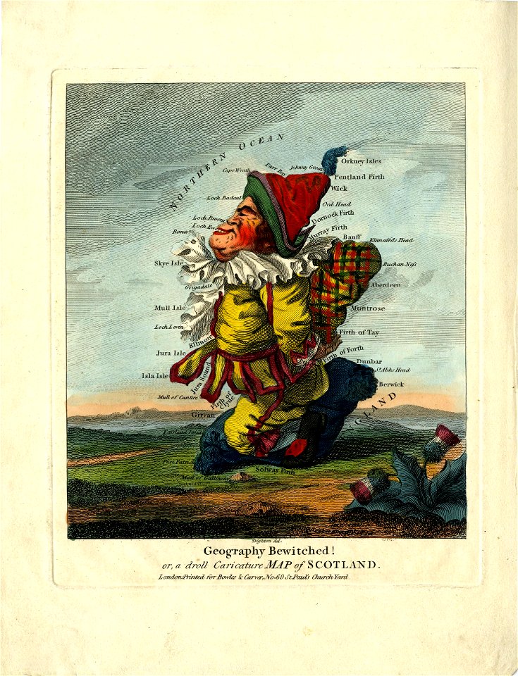
satirical prints in the british museum
works after robert dighton
satirical prints in the british museum
works after robert dighton
carte particulière des costes de l'afrique qui comprend le royaume de gualata ... - btv1b8595466g
maps by pieter mortier
carte particulière des costes de l'afrique qui comprend le royaume de gualata ... - btv1b8595466g
maps by pieter mortier
map of modern syria by philippe de la rué
1650s maps of palestine
1690s maps of the ottoman empire
guillaume sanson
bibliothèque nationale de france
maps by thomas kitchin
17th-century portrait paintings
baroque
david rumsey historical map collection
john emslie
carte de barbarie, nigritie, guinée par guillaume delisle (1707)
university of washington
drawings by maria vos in the rijksmuseum amsterdam
flowers in art of the netherlands
celeberrimi fluvii albis nova delineatio by willem janszoon blaeu
maps in the staats- und universitätsbibliothek hamburg
a visit to the indian archipelago, in h.m. ship maeander
a visit to the indian archipelago (1853) by keppel
tresor des cartes geographiques (1659)
bibliothèque nationale de france
italia - di matteo greuter... - btv1b525056959
old maps of italy
tresor des cartes geographiques (1659)
bibliothèque nationale de france
maps from gallica
guides joanne
italia - di matteo greuter... - btv1b525056959
old maps of calabria
italia - di matteo greuter... - btv1b525056959
old maps of apulia
tresor des cartes geographiques (1659)
bibliothèque nationale de france
bibliothèque nationale de france
cartouches by tomas lópez
tresor des cartes geographiques (1659)
bibliothèque nationale de france
italia - di matteo greuter... - btv1b525056959
1650s maps of tuscany
glaciers and glaciation (1910)
maps of prince william sound
ndl-dc 1312947-azuma nishiki-e
nihonga
italia - di matteo greuter... - btv1b525056959
old maps of sicily
mappe-monde geo-hydrographique (sanson and jaillot, 1674)
bibliothèque nationale de france
the bottom of the sea (1870)
maps of the adriatic sea
6001 - 6100 of 9,296
Next page
/ 93